---
title: "List of 56 Nations"
key: "List_of_56_Nations"
url: "https://nithyanandapedia.org/wiki/List_of_56_Nations"
markdown_url: "https://nithyanandapedia.org/wiki/List_of_56_Nations.md"
type: "article"
language: "en"
categories:
- "KAILASA PEDIA PAGE"
updated: "2021-06-13T03:06:23.000Z"
description: "Deshas and capitals (source as on 18 October 2018: from various puranas, bhagavatam, bhavisya purana, and mahabharat, ramayana etc."
lead_image: "https://nithyanandapedia-images.nithyananda.ai/wiki-images/320/3/37/696px-Img_56_Deshas_1.webp"
---
# List of 56 Nations
# **Deshas and capitals**
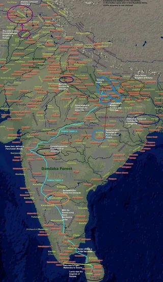
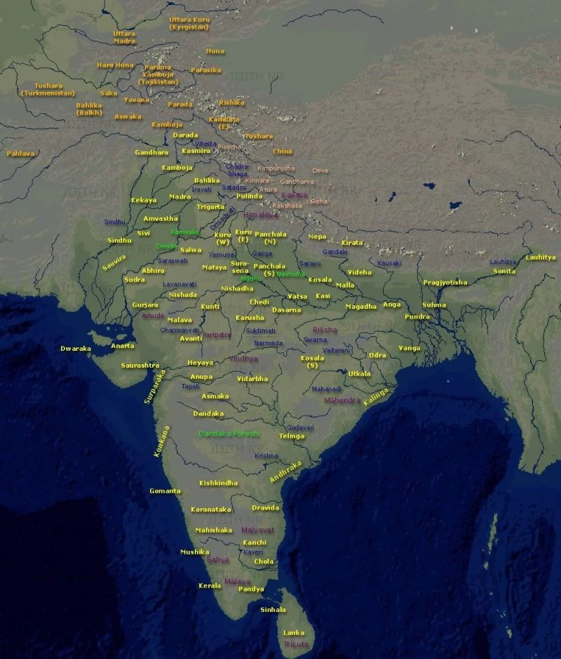
(source as on 18 October 2018: from various puranas, bhagavatam, bhavisya purana, and mahabharat, ramayana etc. and bharat varsha map location directions, some of the capital names changed over ages.)
| | | |
| --- | --- | --- |
| **Desha** | **Direction**
**Bharat-Varsha** | **Capital** |
| **Panchala** | North | 1. **Ahichatra** (North) (kshetra of snakes)
2. **Kampilya **(southern)
*\*Mahabharat* |
| **Kuninda (or Kulinda)**
**Central Himalayas** (located in the modern state of Uttarakhand and southern areas of Himachal in northern India.) | North | **Nāgarkot** |
| **Kinnara** | North | **Kinnara** |
| **Kosala (uttar)** | North | **Ayodhya** |
| **Matysa**
**(or Machcha tribe)** | North | **Viratapuri or Viratanagar**
1. Associated with Surasenas
2. Founded by King Virata
3. to the south of the Kurus and west of the Yamuna, which separated them from the Panchalas. |
| **Nepa**
**(Nepal)** | North | **Nepalakaksha** |
| **Hara Huṇa** | North (foreign) | |
| **Kashmira** | North west | **Srinagara**
1. Maharishi Kashyapa or a descendant of this sage lived here. |
| **Madra** | North west | **Sākala**
(modern Sialkot in the Punjab province of Pakistan). |
| **Kekeya**
(also known as Kekaya, Kaikaya, Kaikeya etc. part of Vahika country.) (The Kekayas occupied the land now comprised by three districts of Jhelum, Shahpur and Gujerat,all in Pakistan.) | North west | **Rajagriha or Girivraja**
(as per Ramayana) |
| **Sindhu** | North west | **Vrsadarbhpura** |
| **Kamboja** | North west | Rajapura (Rajauri)
1. The Kambojas are also described as a royal clan of the Sakas.
2. as former kshatriyas (Warriors caste) who had degraded through a failure to abide by Hindu sacred rituals. |
| **Kosala (dakshina)**
**(south central)** (place of Sri Rama’s mother Kaushalya) | North-central | **Sripura** |
| **Kasi;**
**Benaras or Banaras** | North-east | **Varanasi**
1. The *Matsya Purana* calls Kashi as *Kausika* and *Kaushaka* |
| **Malla**
**(or Mallarashtra)**
- north of Magadha desha | North-east | \# **Kusavati (modern Kasia near Gorakhpur)**
1. **Pava (modern Fazilnagar 12 miles from Kasia)**
2. The Mallas are mentioned by Manusmriti as Vratya Kshatriyas.
3. chosen death place of Mahavira and Gautama Buddha. |
| **Kuru**
(from the Puru dynasty)
1. | North | **Indraprastha**
**Hastinapura (delhi)** |
| **Kuru (W)**
1. | North | **Kurukshetra**
1. As per Mahabharat, the Kuru - Kshetra (extending till panchala) lay between the rivers Sarasvati and Drsadvati, in eastern punjab. This land has been also called Brahma-vrata in Manusmriti. |
| **Vatsa or Vamsa**
**(branch of Kuru)** | North | **Kausambi**
1. village ‘kosam’
2. corresponding to territory of Allahabad (today). |
| **Magadha** | East | **Pataliputra**
**Kusagārapura**
1. was bound in the north by the river Ganges, in the east by the river Champa, in the south by Vindhya mountains and in the west by the river Sona.
Ancient great country, Magadha desha comprised of the present Patna and Gaya districts of Bihar and its capital originally at Girivaja-Rajagrha (Rajgir) and then Pāṭaliputra (near Patna. |
| **Gaya desha**
**(also called Kikata)**
- south of Magadha desha | East | **Gaya** |
| **Videha** | East | **Mithila** |
| **Anga**
**(east of Magadha)** | East | **Champa** |
| **Pragjyotisha**
The word Pragjyotishpura derived from Sanskrit words "Prag", "Jyotisha" and "Pura" meaning 'city of eastern light' otherwise 'city of eastern astrology'. | East | **Pragjyotishpura (now Guwahati)**
In the Kishkindha Kanda of the Ramayana, the kingdom is placed in the west near Mount Varaha on the sea.
1. When Krishna went to Pragjyotisha, Naraka with all the Danavas did not succeed in seizing him there. |
| **Vanga** | East | **Chandrakanta** |
| **Pundra**
(- Was ruled by Paundra Vasudeva, who imitated Sri Krishna and was killed in battle with Him.
1. based in West Bengal and Bangladesh) | East | **Paundra** |
| **Kalinga**
**(eastern coast, Orisha)** | East | **Rajapura** |
| **Suhma** | East | |
| **Odra** | East | **Katak** |
| **Sonita** | East | **Sonitapura**
(Aniruddha, Sri Krishna’a son married the daughter of his kingdom) |
| **Utkala (Utpala, Okkal)**
(jagannatha temple) was located in the northern and eastern portion of the modern-day Indian state of Odisha and also included the districts of Bankura, Purulia and Midnapore districts of West Bengal. | East | **Puri** |
| **Saraswata** | West | **Saraswati** |
| **Abhira**
(Comprises parts of Northern Konkan and Nasik region. ) | West | **Nasik** |
| **Surasena**
(Andhakas and Vrishnis dynasty) | Western/Central | **Mathura**
1. The country of the Surasenas lay to the east of Matsya and west of Yamuna.
2. This corresponds roughly to the Brij region of Uttar Pradesh, Haryana and Rajasthan and Gwalior region of Madhya Pradesh. |
| **Anarta**
1. roughly forming the northern Gujarat state of India. | Western/Central | **Prabhas** |
| **Dwarika** | Western/Central | **Dwarikapuri** |
| **Saurashtra**
(southern Gujarat) **Gurjara or Gurjaradesha or Goparasthra** (eastern Rajasthan and northern Gujarat) | Western/Central | **Gomantaka**
1. The name Surat, a modern city of Gujarat, is derived from the name Saurashtra.
2. one among the many kingdoms ruled by Yadava kings in the central and western India. |
| **Chedi**
**(Jhansi district in Uttar Pradesh)**
1. roughly in the Bundelkhand division of Madhya Pradesh regions to the south of river Yamuna along the river Ken. | Western/Central | **Suktimati (Sukti)** |
| **Kunti**
**(North to Avanti Kingdom)** | Western/Central | **Kunti Bhoja** |
| **Avanti** | Western/Central | **Mahishamati (southern capital)**
**Ujjaini (northern capital)**
1. The country of Avanti roughly corresponded to modern Malwa, Nimar and adjoining parts of the Madhya Pradesh.
2. Both Mahishmati and Ujjaini stood on the *southern high road* called *Dakshinapatha* extending from Rajagriha to Pratishthana (modern Paithan). |
| **Malava**
**(West to Avanti Kingdom)** | Western/Central | **Udayapuri, Madhyamika** |
| **Hehaye**
(also known as Haihaya, Haiheya, Heiheya) | Western/Central | **Mahishmati**
1. on the banks of river Narmada in present-day Madhya Pradesh. |
| **Dasarna**
(present madhya pradesh) | Western/Central | **Vidisha** |
| **Pulinda**
(the Vindhyan region in Central India) | Central | **Pulinda-nagara**
(located in present-day Jabalpur District of Madhya Pradesh state.) |
| **Vidarbha**
(northeastern Maharastra) | Central | **Kundinapura**
1. **Sri Krishna’s wife Rukmini from Vidarbha** |
| **Anupa** | Central | **Surpana** |
| **Shurapaka**
(near the Western sea, close to the mouth of river Narmada. identified with modern Sopara, in Palgar district north of Mumbai) | Central/West | **Kalyani or Matanga** |
| **Konkana**
**(Konkan region (coastal region) of Maharashtra)**
1. The ancient Saptakonkana is a slightly larger region described in the Sahyadrikhanda of Skanda Purana, which refers to it as Parashuramakshetra (Area of Parasurama). | Central | **Puri** |
| **Dandaka**
**(It is roughly the Nashik District, Maharashtra)** | Central | **Janasthana** |
| **Vraji** | | **Vaishali**
1. **chief city Mithila** |
| **Gandhara** | north-west | **Pushkalavati**
**Puruṣapura (Peshawar)** **Takshashila**
1. In Treta Yuga, before Lord Rama, during the reigns of Muchukunda, the kingdom of Gandhara was founded by the Druhyu prince Gandhara who was the son of King Angara of Druhyu Dynasty.
2. During Ramayana, King Nagnajit a contemporary of Lord Rama was defeated and killed by Rama's brother Bharata and Bharata's 1st son Taksha established Takshasila (Taxila) in Gandhara Kingdom on the banks of river Sindhu and Pushkara established Pushkaravati or Purushapura (Pushkar) in Gandharva tribe on the banks of river Saraswati. In Dvapara Yuga, Gandhara prince Shakuni was the root of all the conspiracies. |
| **Pallava** | South | **Kanchi/Kanchipuram** |
| **Andhra or Andhraka** | South | **Amravati ((Dharanikota)**
(Historically, Amaravati was the capital of Satavahanas, the first great Andhra kings who ruled from 230 BC to 220 BC after the downfall of the Mauryan empire.) |
| **Kishkindha**
(- kingdom of Bali, Sugriva during Ramayana around the Tungabhadra river (then known as Pampa Saras)
1. belongs to Koppal district, Karnataka.) | South | **Kishkindha**
**(Mt. Rishimukha)** |
| **Pandya** | South | **Madura**
**(**present day Madurai) |
| **Kerala (Chera)** | South | **Kodungallur (or Makotai)**
**Kollam** |
| **Chola or Chola Nadu**
(region that includes the modern-day Tiruchirapalli District, Tiruvarur District, Nagapattinam District, Ariyalur District, Perambalur district, Pudukkottai district, Thanjavur District in Tamil Nadu and Karaikal District) | South | **Cholamandalam**
Early Cholas: Poompuhar, Urayur, Tiruvarur Medieval Cholas: Pazhaiyaarai, Thanjavur, Gangaikonda Cholapuram |
| **Telinga**
(present telengana) Kakatiya dynasty | South | **Kotalingala**
**(has the Koteswara Siddeshwara Temple.)** |
| **Gomanta** | South | **Gokarna** |
| **Karnataka**
**Mahishakha** | South | **Mahishapuri (mysore)** |
| **Mushika (kolaputra)** | South | **Mushikapuri** |
| **Tulunga (Tulu Nadu)** | South | **Sauparnika** |
| **Lanka**
**(present Srilanka)** | South | **Lankapuri** |
| **Sinhala**
**(near lanka)** | South | '***Anuradhapuri'*** |
*Brahmarshi-desha*, 'the county of the holy sages,' includes the territories of the Kurus, Matsyas, Panchalas and Shurasenas (i.e., the eastern half of the State of Patiala and of the Delhi division of the Punjab, the Alwar State and adjacent territory in Rajputana, the region which lies between the Ganges and the Jumna, and the Muttra District in the United Provinces).
---
Categories: [KAILASA PEDIA PAGE](https://nithyanandapedia.org/wiki/Category:KAILASA_PEDIA_PAGE.md)
Source: